Agricultural Drones: Transforming Modern Farm Operations
Modern farming continues to evolve as technology helps growers improve efficiency, reduce waste, and make better decisions. Among the most impactful innovations in recent years are Agricultural Drones, which have become valuable tools for farms of all sizes across the United States.
From crop monitoring and field mapping to targeted spraying and data collection, drones provide farmers with detailed insights that were once difficult or expensive to obtain. As Smart Farming practices expand, UAV Technology is helping producers improve yields, manage resources more effectively, and respond quickly to changing field conditions. Understanding how agricultural drones work and where they fit into modern agriculture can help farmers stay competitive in a rapidly changing industry.
What Are Agricultural Drones?
Agricultural drones are unmanned aerial vehicles (UAVs) designed specifically for farming and agricultural operations. Equipped with cameras, sensors, GPS systems, and advanced software, these aircraft collect valuable information about crops, soil conditions, irrigation systems, and overall farm performance.
A Brief History and Evolution
Early drone technology was primarily used for military and research purposes. As hardware became more affordable and software capabilities improved, farmers began adopting drones for commercial agricultural applications.
Today’s drones offer far more than aerial photography. Advanced systems can perform Remote Sensing, create detailed maps, analyze crop health, and even apply fertilizers and pesticides. Modern agricultural drones are now integrated into broader Precision Agriculture strategies that use data to optimize farm management decisions.
As battery life, imaging technology, and automation continue to improve, drones are becoming an essential part of daily farm operations.
Benefits of Drones in Agriculture
The growing popularity of drones is largely driven by the many Benefits of Drones in Agriculture. These systems help farmers gather accurate information quickly while reducing labor and operational costs.
Enhanced Crop Monitoring
Traditional crop inspections often require significant time and manpower. Drones can survey hundreds of acres in a fraction of the time.
High-resolution imagery allows farmers to identify crop stress, nutrient deficiencies, irrigation issues, and disease outbreaks before they become widespread problems. Early detection enables faster intervention and reduces potential losses.
Improved Productivity
Farmers can use drone-generated data to prioritize field activities and allocate resources more efficiently. Instead of treating entire fields uniformly, they can focus attention on specific problem areas.
This targeted approach improves productivity by reducing unnecessary applications of fertilizers, pesticides, and water.
Reduced Operational Costs
Labor shortages remain a challenge for many agricultural operations. Drones help reduce the amount of manual field scouting required while increasing the accuracy of inspections.
By identifying issues early and improving resource allocation, farms often experience lower operating costs and higher returns on investment.
Data-Driven Decision-Making
One of the greatest advantages of drone technology is access to accurate, real-time information.
Data collected through aerial surveys can support decisions related to planting schedules, irrigation management, fertilizer applications, and harvesting strategies. This information helps farmers make informed choices rather than relying solely on visual observations or historical trends.
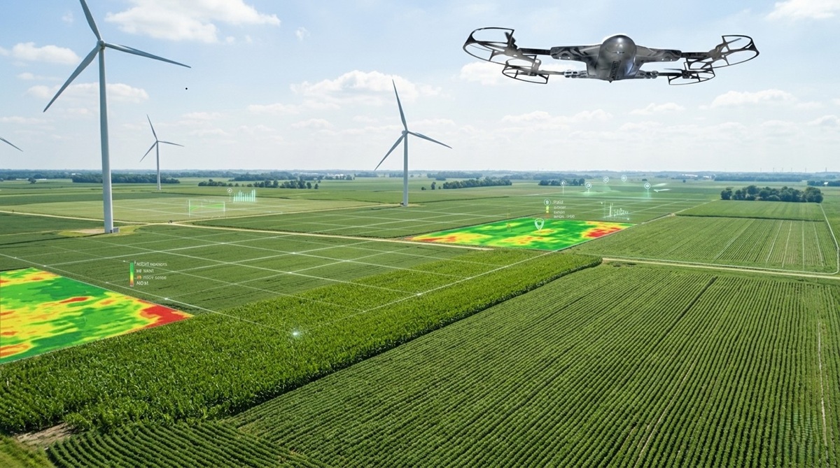
How Agriculture Drone Mapping Improves Farm Management
Agriculture Drone Mapping has become one of the most valuable applications of drone technology. Mapping provides a detailed visual representation of fields and helps farmers understand conditions that may not be visible from ground level.
Field Analysis
Drone mapping creates accurate topographic and orthomosaic maps that provide a complete view of agricultural land.
Farmers can identify elevation changes, drainage patterns, erosion risks, and field boundaries. These insights support better planning for planting, irrigation, and infrastructure development.
Soil Assessment
Before planting begins, drones can collect data that helps evaluate soil conditions.
Farmers can analyze soil variability, moisture levels, and terrain characteristics to determine the most effective planting strategies. This information contributes to more efficient land use and stronger crop establishment.
Crop Health Monitoring
Multispectral and thermal imaging sensors enable drones to detect subtle variations in crop health.
By measuring plant reflectance and temperature differences, drones can identify stress caused by nutrient deficiencies, pests, diseases, or inadequate irrigation. Early identification allows corrective measures before damage spreads throughout the field.
Yield Forecasting
Drone-generated data supports more accurate yield predictions throughout the growing season.
Combining aerial imagery with historical records and weather information helps producers estimate harvest volumes and plan storage, transportation, and marketing activities more effectively.
Applications of Agricultural Spray Drones
Among the fastest-growing segments of agricultural technology are Agricultural Spray Drones. These systems are designed to apply crop protection products and nutrients with exceptional precision.
Precision Spraying
Traditional spraying methods may result in uneven coverage or overspray. Spray drones use GPS-guided flight paths and variable-rate technology to apply products exactly where they are needed.
This precision minimizes waste and improves application efficiency.
Fertilizer Application
Drones can distribute liquid fertilizers across fields quickly and accurately.
Rather than applying fertilizer uniformly across entire fields, farmers can target specific zones that require additional nutrients. This reduces costs while supporting healthier crop development.
Pest and Disease Management
Agricultural spray drones help farmers respond rapidly to pest infestations and disease outbreaks.
Because drones can access difficult terrain and sensitive crop areas, treatments can be applied more efficiently than with some ground-based equipment. Faster response times often reduce crop losses and limit the spread of problems.
Environmental Benefits
Targeted applications reduce chemical usage and minimize environmental impact.
Precision spraying decreases runoff, lowers soil compaction, and reduces exposure of non-target plants and wildlife to agricultural chemicals. These benefits support sustainability goals while maintaining crop productivity.
Understanding Agriculture Drone Services
Many farms choose to work with professional providers that offer specialized Agriculture Drone Services.
These services allow growers to access advanced drone capabilities without investing in equipment, software, or pilot training.
Surveying Services
Professional drone operators conduct aerial surveys that provide detailed field maps and terrain analysis.
These surveys support land development projects, drainage planning, irrigation system design, and crop management initiatives.
Imaging and Remote Sensing
Advanced drone services often include multispectral, thermal, and high-resolution imaging.
These technologies provide deeper insights into crop performance and allow farmers to detect issues that are not visible through standard inspections.
Monitoring Programs
Some service providers offer recurring monitoring throughout the growing season.
Regular flights generate updated information that helps farmers track crop development, identify emerging problems, and evaluate management strategies.
Data Analytics
Collecting information is only part of the process. Many Agriculture Drone Services also provide detailed analytics and reporting.
Specialized software transforms aerial imagery into actionable insights that support Farm Management decisions. Reports may include vegetation indexes, crop health assessments, irrigation analysis, and yield projections.
Why Precision Agriculture Drones Are the Future of Farming
The future of agriculture is increasingly connected, automated, and data-driven. Precision Agriculture Drones play a central role in this transformation.
Integration with Artificial Intelligence
Many drone platforms now incorporate artificial intelligence and machine learning technologies.
AI-powered systems can automatically identify crop stress, classify weeds, detect diseases, and generate recommendations for corrective action. This automation reduces analysis time and improves decision accuracy.
Smart Farming Technologies
Drones are becoming integrated with broader Smart Farming ecosystems.
Data collected from drones can be combined with information from weather stations, soil sensors, irrigation systems, and farm management software. This interconnected approach provides a comprehensive view of farm performance.
Sustainability Benefits
Sustainability remains a priority for both farmers and consumers.
Precision Agriculture Drones help reduce water consumption, optimize fertilizer use, and minimize pesticide applications. These improvements support environmental stewardship while maintaining productivity and profitability.
Future Industry Trends
Several emerging trends are expected to accelerate drone adoption across U.S. agriculture.
These include autonomous flight systems, longer battery life, improved sensor technology, real-time analytics, and expanded regulatory approvals. As capabilities continue to improve, drones will become even more valuable tools for commercial farming operations.
Challenges and Considerations
While drones offer significant advantages, farmers should also consider several practical challenges before implementation.
Regulatory Requirements
Drone operations in the United States are regulated by the Federal Aviation Administration (FAA).
Commercial drone operators must comply with applicable rules regarding pilot certification, flight restrictions, and operational safety. Farmers should understand these requirements before using drones for business purposes.
Training and Skill Development
Operating drones effectively requires training and experience.
Pilots must understand flight procedures, safety protocols, sensor operation, and data interpretation. Ongoing education is often necessary as technologies continue to evolve.
Weather Limitations
Weather conditions can affect drone performance and data quality.
High winds, rain, fog, and extreme temperatures may limit flight opportunities. Farmers should plan operations around suitable weather windows to ensure reliable results.
Initial Investment
Purchasing drone equipment, sensors, software, and training can require a substantial upfront investment.
Although many farms achieve long-term savings and efficiency gains, evaluating costs and expected returns remains an important part of implementation planning.
Conclusion
The adoption of Agricultural Drones is reshaping how farms operate across the United States. These advanced tools support crop monitoring, Agriculture Drone Mapping, precision spraying, data collection, and resource management with unprecedented accuracy.
From improving productivity and reducing costs to advancing sustainability and Smart Farming initiatives, drones offer practical solutions to many of agriculture's modern challenges. As UAV Technology continues to evolve, Agricultural Drones will play an increasingly important role in helping farmers make informed decisions, maximize yields, and build more resilient agricultural operations for the future.
FAQs
What are agricultural drones used for?
Agricultural drones are used for crop monitoring, field mapping, spraying, soil analysis, Remote Sensing, and collecting data that supports farm management decisions.
How do agricultural drones improve crop health?
Drones identify crop stress, disease, pest infestations, and irrigation issues early, allowing farmers to take corrective action before problems spread.
Are agricultural spray drones effective?
Yes. Agricultural Spray Drones provide precise application of pesticides, herbicides, and fertilizers, reducing waste while improving coverage and efficiency.
What is agriculture drone mapping?
Agriculture Drone Mapping uses aerial imagery and GPS data to create detailed maps that help farmers analyze field conditions, monitor crops, and forecast yields.
Do farmers need a license to operate drones?
In many commercial agricultural applications, drone operators must comply with FAA regulations and may need appropriate certification depending on how the drone is used.

About Premium Author
This post has been authored and published by one of our premium contributors, who are experts in their fields. They bring high-quality, well-researched content that adds significant value to our platform.


Popular Categories
Stay Connected
Recent Posts